UK Argo and the ANDRO Atlas (28th July 2011)
Collectively, the Argo dataset provides a novel opportunity to investigate sub-surface ocean circulation. Since 2000, data from more tan 6000 Argo floats have been collected worldwide, producing over 1,000,000 hydrographic profiles.
Scientific efforts to understand the oceans' sub-surface circulation have been hindered by several data issues. These issues include invalid data where floats have been grounded, missing data and metadata such as position or depth information, and inconsistent international metadata standards.
To address this, the ANDRO Atlas endeavoured to produce a reliable global atlas of Argo ocean sub-surface trajectories. ANDRO is led by Michel Ollitrault (Ifremer, France) with much of the analysis conducted by Jean-Philippe Rannou (Altran, France).
The Atlas covers 10 years of Argo data spanning 1999 to 2009, with contributions from as many of the Argo participant countries as possible. Once complete, it will be an unprecedented database of direct and absolute measurements of the ocean circulation in the upper 2000 metres.
As the Data Assembly Centre (DAC) for UK Argo, Ireland, Mauritius and Saudi Aradia, BODC submitted more than 30,000 raw data profiles from over 300 floats to ANDRO in 2010. Analysis of these data is now complete and has contributed to the Atlas in the North Atlantic, South Atlantic, Indian and Southern oceans.
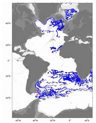
UK Argo contribution to ANDRO for the layer 750-1250 dbar in the Atlantic Ocean
Feedback from the data analysis will be used by BODC over the coming years to improve the quality and scientific value of the BODC-hosted Argo data. Feedback was primarily related to inconsistent metadata standards, as such it is anticipated to form the basis for the development of new international standard practices within the Argo community.