Circling the North Atlantic (15th January 2011)
Float 52329: Circling the North Atlantic
One UK float, deployed in the North Atlantic during October 2005, has completed 187 cycles and is approaching a complete loop of the North Atlantic sub-polar gyre — a large, permanent, circular rotation of ocean water. The float continues to supply good profiles and application of the Owens and Wong (2009) calibration method reveals no significant sensor drift over its lifetime. More details of its voyage and the data it has collected are provided below.
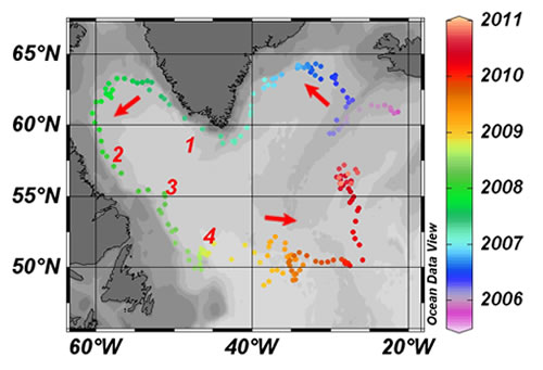
The float followed the continental shelf-edge around Greenland and Newfoundland coasts before heading east at 50°N.
- October 2005 — a Apex float WMO# 6900388 is deployed at 61° 15.6' N, 20° 0.6'
W.
The float operates a 10-day cycle, whereby it drifts for 9 days at a depth of 1000 m to provide circulation information before descending to a depth of 2000 m. Once it reaches 2000 m it begins an ascent to the sea surface, as it rises it measures the water temperature, salinity and pressure. At the surface it transmits the data it has collected to a receiving station via satellite and descends to a depth of 1000 m to repeat the cycle.
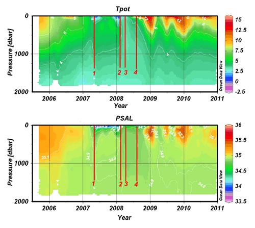
Potential temperature (Tpot) and salinity (PSAL) as measured by float 52329 during its voyage.
- Spring 2007 (1) — the float passes the southern tip of Greenland and encounters its first injection of cold and fresh water into surface layers. This water originates in the Arctic and despite its low temperature remains buoyant due to its low salt content.
- January 2008 (2) — a similar cold and fresh water surface event is seen, however by this time the float has crossed the Labrador Sea and is following the Newfoundland continental shelf. During this period it travels up to 200 km between its 10 day cycles, which equates to an average speed of 20 cm s-1 whilst drifting at a depth of 1000 m.
- February/March 2008 (3) — the float's data shows clear evidence that the upper 2000 m of the water column are well mixed, with both temperature and salinity remaining more or less constant. This seasonal deepening of the mixed layer, due to winter storms, is present but not so obvious in the data from the other years.
- Autumn 2008 (4) — the float meets the northern boundary of the Gulf Stream and is deflected eastwards.
- Autumn 2008 onwards (4+) — the float's increasingly meandering path and the fleeting encounters with warm and cold water features as it crosses the eddy field illustrate the Gulf Stream's energetic and unstable flow. Although there is always a seasonal signal present in surface water temperatures, during the floats journey at the boundary of the Gulf Stream a more chaotic signal is superimposed due to interaction with the fringes of the warmer current.
The overall journey helps illustrate the circulation features in the North Atlantic. In particular the narrow, linear flow around the north of the basin, which contrasts with the turbulent progress of the Gulf Stream in the south. Full size and additional data plots are also available in an Adobe PDF (2 MB) document.
With over 3000 floats active at any one time, it is inevitable that paths may cross. The final plot shows the path of our float (red) when compared with an Argo Canada float (blue). These are overlain on an annually averaged temperature colour map at 1000 m depth supplied by the UK Met Office FOAM hindcast model.
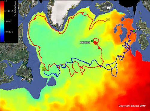
Float WMO 6900388 (red) and float WMO 4900628 (blue) trajectories, overlaid on an annually averaged temperature colourmap of the North Atlantic at 1000 m depth.
It appears that our float has followed the north-western arm of the North Atlantic current and may commence a second circuit. Meanwhile the Canadian float has taken an alternative route traveling up the Rockall Trough, another main arm of the current, which carries warm water toward Norway and the Polar regions.
References
Owens W.B., Wong A.P.S., 2009. An improved calibration method for the drift of the conductivity sensor on autonomous CTD profiling floats by theta-s climatology, Deep-Sea Research Part I: Oceanographic Research Papers, 56(3), 450-457.
Schlitzer R., 2010. Ocean Data View, http://odv.awi.de