Forecasting Ocean Assimilation Model
FOAM model illustration
The Met Office Forecasting Ocean Assimilation Model (FOAM) system provides operational analyses and 5-day forecasts of ocean temperature, salinity, currents and sea-ice on a daily basis. It assimilates Argo data as well as other data types including satellite altimeter sea surface height data and sea surface temperature data.
The main aims are to analyse and forecast the mesoscale structure of the ocean and to use the analyses produced by FOAM to monitor the climate of the oceans. For both of these aims, the Argo data are crucial. The only data available which can directly resolve the dynamical structure at the mesoscale is the satellite altimeter sea surface height data.
The method used to assimilate the altimeter data makes no changes to the water mass properties of the model and so the only way in which these can be altered is through direct assimilation of in situ profile data, such as from Argo.
FOAM Antarctic configuration
- 1/4 degree on a rotated grid with north pole at 5°N 75°E
- 20 vertical levels
- Grid dimensions (y,x) — 400 x 420
- Source bathymetry data set — GEBCO
- First tracer point in model (at SW corner) — 50°S 120°E
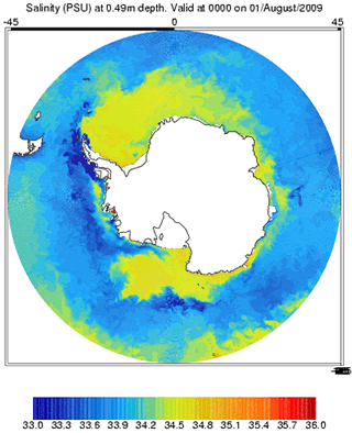
FOAM images
Images of potential temperature, salinity and velocity at five metres and 995.5 m are supplied by the Met Office to the British Oceanographic Data Centre at monthly intervals. These may be viewed by selecting the relevant parameter/period from the form below.
The images are also available as animations covering the period July 2004 to February 2009 for potential temperature, salinity and velocity (currents) respectively.